Random image from our India photo collection
Karnataka
Physical Features
The state of Karnataka is part of two well-defined regions of India, namely the Deccan Plateau and the Coastal Plains and Islands. It can be further divided into four physiographic regions-the Northern Karnataka Plateau, Central Karnataka Plateau, Southern Karnataka Plateau and the Coastal Karnataka Region.
The Northern Karnataka Plateau, at an elevation of 300 to 600 meter, is largely composed of the Deccan Trap. It represents a monotonous, treeless extensive plateau landscape rich in black cotton soils.
The Central Karnataka Plateau is the area between the Northern and Southern Karnataka Plateaus, which results in the general elevation varying between 450 and 700 meter. This region represents the area of the Tungabhadra basin.
The Southern Karnataka Plateau covers the area of the Cauvery river basin lying in Karnataka. The region is situated between 600 and 900 meter above sea level and is encircled by the Western Ghats in the west and south.
The Western Ghats and the coastal plains constitute the Coastal Karnataka Region. The coastal stretch, with an average width of 50 to 80 km, covers about 267 km from north to south.
There are chains of mountains, the highest being the Mullayyana Giri (1,925m).
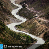
The state possesses six percent of the total water resources in the country as there are many rivers flowing through it. The most famous among them are the Krishna, Cauvery, Godavari, North Pennar, South Pennar and Palar.
Go back
The Northern Karnataka Plateau, at an elevation of 300 to 600 meter, is largely composed of the Deccan Trap. It represents a monotonous, treeless extensive plateau landscape rich in black cotton soils.
The Central Karnataka Plateau is the area between the Northern and Southern Karnataka Plateaus, which results in the general elevation varying between 450 and 700 meter. This region represents the area of the Tungabhadra basin.
The Southern Karnataka Plateau covers the area of the Cauvery river basin lying in Karnataka. The region is situated between 600 and 900 meter above sea level and is encircled by the Western Ghats in the west and south.
The Western Ghats and the coastal plains constitute the Coastal Karnataka Region. The coastal stretch, with an average width of 50 to 80 km, covers about 267 km from north to south.
There are chains of mountains, the highest being the Mullayyana Giri (1,925m).
The state possesses six percent of the total water resources in the country as there are many rivers flowing through it. The most famous among them are the Krishna, Cauvery, Godavari, North Pennar, South Pennar and Palar.
Go back